A named tropical storm had dramatic effects on a group of aquatic ecosystems last year, but the affected waters were not what you might expect. They were freshwater lakes and reservoirs spread across the northeastern U.S. and southeastern Canada, some located far inland from the coast. A new study sheds light on the consequences of these extreme events for inland waters across the globe.
When Hurricane Sandy struck the northeastern U.S. at the end of October, another powerful storm had yet to fade from memory. How could anyone forget the widespread power outages and images from Irene that showed historic covered bridges washing down rivers in Vermont or air photos of muddy water filling national treasures like the Chesapeake Bay, Hudson River, and Lake Champlain?
The nature of the impacts of the two storms couldn’t have been more different. Sandy caused extensive damage to densely populated areas along the coast, making it one of the most devastating storms to make landfall in the U.S. Irene, on the other hand, unleashed its fury further inland, bringing severe flooding to areas as far north as the St. Lawrence River Valley in Quebec.
With extreme weather events expected to increase as the climate warms, studying the ecological effects of these storms takes on new importance. The past focus has been on the damage to coastal areas, but as Irene has taught us, impacts to inland waters are also a concern. This is why researchers from lakes affected by the 2011 storm teamed up to see what they could learn about its effects.
The unique study was possible because scientists had previously deployed automated sensors in nine lakes situated in a variety of landscape settings across the affected region. Local lake associations and New York City’s water supply program use the high-tech devices to help inform management decisions. Researchers who study these lakes were already collaborating as members of the Global Lake Ecological Observatory Network (GLEON).
The automated sensors are mounted on buoys and measure the effects in real-time. During Irene, they collected data from each lake every ten minutes to six hours, depending on the lake. The high frequency data, combined with the network of citizens and scientists observing the lakes and long-term monitoring records, allowed them to make new observations about the effects of extreme weather events.
Using buoy data to compare the impacts of Irene was the brainchild of Kathleen C. Weathers, senior scientist at the Cary Institute of Ecosystem Studies and co-chair of GLEON. Her family has long ties to Sunapee, so she also serves as research director for the Lake Sunapee Protective Association (LSPA) and was instrumental in helping the group establish a monitoring buoy in the lake.
“The high frequency data from GLEON buoys are ideal for making cross-lake comparisons,” Weathers said. “Not only can citizens and scientists learn more about their own lake, they can compare results with researchers working on other lakes around the world and therefore contribute to regional- and global-scale studies, which is a remarkable opportunity.”
Several years ago, Friends of the Lake, a local citizens group on Lake Lillinonah, Connecticut’s second largest lake, invited Jennifer L. Klug, a lake scientist and associate professor at Fairfield University, to collaborate with them. Together they set up a research and monitoring program that uses sensors mounted on a buoy and an onshore weather station and includes a role for citizen scientists. It’s a win-win for all involved. “Friends of the Lake gets information they need about the lake, I can get my students involved in relevant research, and the data can be shared as part of an active global network,” Klug told me.
“We started from scratch a few years ago,” said Klug. “LSPA and GLEON members gave us invaluable advice as we designed and deployed our monitoring program.”
The results of the nine-lake study were published recently in Environmental Science & Technology. Klug, the lead investigator, told me that this may be the first time scientists have conducted a cross-lake comparison using high frequency data for a single storm event anywhere in the world.
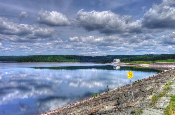
When Irene made landfall in New York in 2011, sensors mounted on a buoy quietly measured its impact to the usually tranquil waters of Lillinonah. Nestled in the granite bedrock of western Connecticut, the lake was created in 1955 by impounding the Housatonic and Shepaug Rivers. Technically a reservoir, the lake is a popular spot for fishing and boating and loved by the residents living along its shores.
Further north on Lake Sunapee in New Hampshire, staff and volunteers at the local lake association braced for the storm while their buoy recorded the lake’s vital signs every 10 minutes. The effects of the storm can be seen in a report on the LSPA website.
Both lakes were located just east of the storm’s track. Other lakes in the study were located on or west of the storm’s track. Even Onondaga in New York and Croche in Quebec, two of the furthest away, felt the effects of rain and wind produced by Irene. Ashokan, Rondout, and Kensico Reservoirs, part of the New York City Water Supply, and Lake Lacawac in Pennsylvania, received the heaviest rainfall.
On August 27, Hurricane Irene made its first landfall in North Carolina and then weakened to a tropical storm as it passed the mouth of the Chesapeake Bay. It was the last full day before the effects of the storm were felt inland in the Northeastern U.S. The buoys on all lakes in the study reported relatively stable conditions. The lakes had yet to begin fall turnover, an annual event where the surface water, warmed by the summer sun, mixes with cooler, denser water underneath.
Irene’s wrath was unleashed the following day when the storm reached its maximum intensity for all of the study lakes except Simoncouche, in Quebec. Within hours, the temperature profiles, as measured every meter or so from the top to the bottom, for all of the lakes were disrupted. Thermal stratification, a characteristic of most north-temperate lakes during the summer and early autumn, is important because it controls fundamental aspects of lake chemistry and the distribution of organisms.
What was interesting is that Simoncouche was one of the most affected by the storm, and a reservoir right under the storm’s track near New York City was one of the least affected. The reason for this, according to the study, was mainly due to both the intensity of the storm and the size of the watershed relative to the volume of the lake. The larger the land area contributing water to the lake and the greater the intensity of the storm, the more disruption within the lake itself. Although it received some of the heaviest rainfall, Kensico Reservoir has a relatively small watershed compared to the other study lakes.
“The most heavily impacted lakes were the ones that received a lot of rain and have a large catchment area,” Klug told me. As the rain falls on the watershed, it flows down through the rivers and streams and eventually reaches the lake. “This was the major mechanism for disrupting the physical stability of the lakes,” she said. “It is also what delivers high levels of sediments, phosphorus, and other unwanted materials to the lake as they wash from land to water.”
The good news is that the lakes recovered relatively quickly in a physical sense. “All but one of the lakes was back to 80% of their pre-storm stability within a week,” Klug said. These are the kind of conclusions that scientists can only reach by comparing effects on a group of lakes in different settings. She added, “We never would have been able to figure that out without the high frequency buoy data.”
I visited Lake Sunapee on a rainy day about six weeks after the storm and can attest to how normal the lake appeared on the surface. I was participating in a GLEON-organized field trip and used my smartphone to connect with the dashboard displaying buoy data on the LSPA website. It was immediately apparent how the temperature and dissolved oxygen in the lake were affected by the same autumn-like conditions I felt at the surface that day.
On Lillinonah, citizen scientists measured the levels of phosphorus before and after the storm. This nutrient is a particular concern in lakes because it contributes to algae blooms. “Phosphorus levels more than doubled after the storm,” Klug told me. She noted that some of the phosphorus eventually may have ended up further downstream, but some likely ended up being retained by the lake. Further complicating matters is a proliferation of zebra mussels in 2012. The tiny molluscs are particularly adept at filtering water and might explain why water quality measurements this past summer were some of the clearest on record. As a result, the group may never now what can be attributed to the storm. Although the lasting effects may be more difficult to determine, Klug said, “The main factor controlling this is the length of time water resides in the lake.” She believes this is why long-term monitoring programs are also important.
Another factor affecting the lakes was the timing of the storm. In the case of Irene, it was near the end of the summer season. Had the storm event occurred earlier in the year, it might have caused a major disruption to the biology of the lakes as well. Klug told me that Lillinonah didn’t have any algae blooms after the storm, in part because the turbid water reduced the amount of light available for aquatic plant growth. She also hypothesized that some of the algae was simply washed out of the lake during the storm.
“Unlike fallen trees, downed power lines, and coastal flooding, the effects of extreme storms on inland aquatic systems are less visible but no less real,” said Klug. She believes that it is all the more reason for lake groups to do what they can to protect the watershed. “The better the land is managed around the lake, the less unwanted material will wash into the lake during a storm event.”
Hurricane Sandy occurred much later in the season. Most of the lakes had already completed fall turnover. The monitoring buoys had been pulled for the winter earlier in the month. The lakes were spared the drenching rains this time, but as a result of the work by Klug and her colleagues, the people who care about these and other lakes will have a better understanding of what can be done to lessen the impact of the next storm that comes along.


