Since 2003, Cary Institute has solicited volunteers to monitor submersed aquatic vegetation (SAV) in the Hudson River as part of research to understand the ecological functions of these plants.
Citizen science observations fill in knowledge for years when aerial photography of plant beds is unavailable and when collected data, such as actual water depth, may not be obtained by other means.
Working independently in teams of two, volunteers work from kayaks and canoes to record observations on plant cover, species presence and water depth at over 100 sites in the river. Three key meetings are held every year—an orientation program in the spring to brief newcomers and review the past year's findings, a training program in July to teach GPS use and data entry, and an appreciation dinner in October to summarize the year's work.
Training volunteers is a critical part of ensuring the quality of data gathered by citizens, but it also provides a valuable chance for scientists to translate their research directly to the public and for the volunteers to gain scientific knowledge and build camaraderie.
If you would like to become a SAV Project volunteer, please contact our Volunteer Coordinator.
Importance of SAV beds
The ecological functions of SAV beds are diverse.
- act as nurseries for numerous larval and juvenile fish and produce organic matter vital to the food web.
- improve the clarity of the river by filtering suspended sediments and reducing algal blooms.
- provide important habitat and feeding areas for waterfowl.
- are an important source of oxygen in the water and are used as a key measure of water quality.
How are the data used?
Good information on abundance, distribution and ecological functions of SAV is necessary for understanding and managing this important resource. Mapping bed location and extent is an essential step in conservation and restoration efforts.
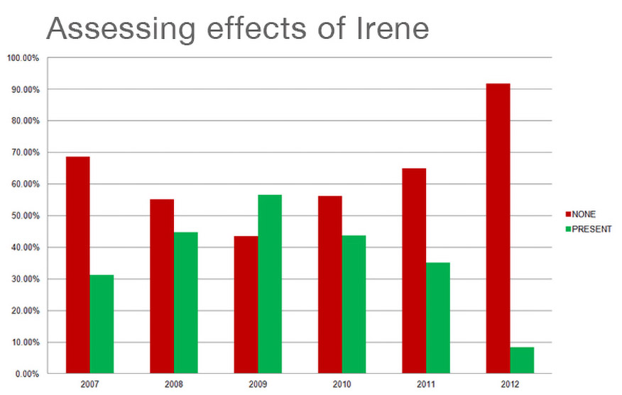
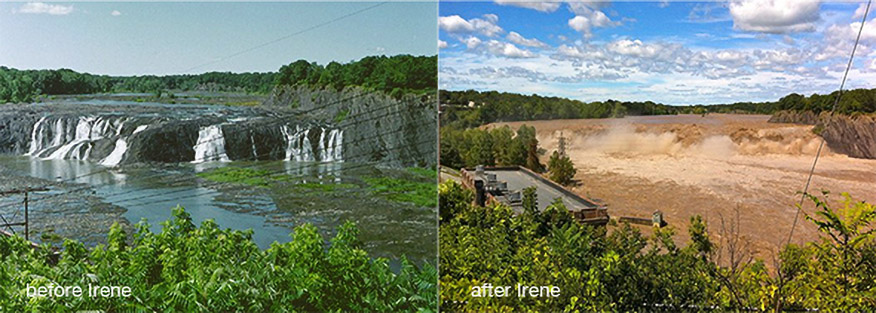
- monitor effects of extreme weather events.
- provided to DEC and other agencies to inform management practices.
- used in scientific research articles and reports.